Newby Lake Fire Incident Overview – Updated

Incident Overview

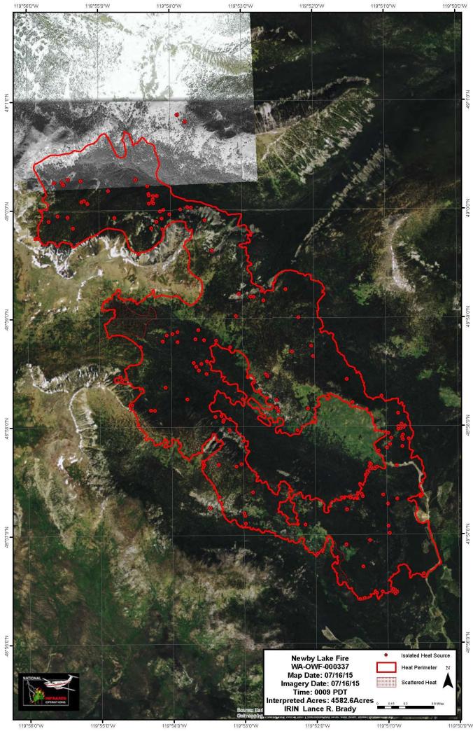
Firefighters have taken advantage of cool and moist conditions over the past few days to make significant progress in building and securing fire lines. Crews in Canada crews will complete mop up and return to base camp when wind conditions permit helicopter flights. On the east flank of the fire firefighters continue to locate and mop up hot spots with the aid of palm infra-red devices In the southeast area, crews will continue securing the 4000 road. Plumbing is complete with hose lays and pumps on the south end, but many hazard snags will be removed to improve fire lines.Crews will continue to build contingency lines in the Branch Creek and Nine Mile Drainage. Winds out of the north-northwest are expected to peak today and give way to a significant warming and drying trend this weekend.

Basic Information

Current as of 7/17/2015, 7:13:37 PM
Incident Type Wildfire
Cause Lightning/natural
Date of Origin Thursday July 02nd, 2015 approx. 01:00 PM
Location 12 miles NW of Loomis, WA.
Incident Commander Ed Lewis – PNW 3

Current Situation

Total Personnel 504
Size 5,065 Acres
Percent of Perimeter Contained 20%
Fuels Involved Timber (Grass and Understory).
Significant Events Fire behavior is minimal. It includes creeping, isolated torching and smoldering.

Outlook

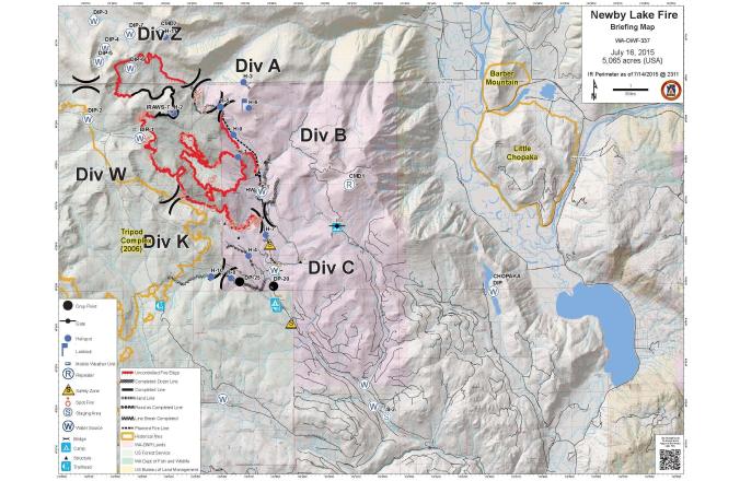
Planned Actions Division A/Z: Aerial patrol.Division B: Identify heat sources and mop-up as appropriate.

Division C: Utilize a combination of direct line and cold trail methods west of the 4000 road to the North Fork of Toats Coulee Creek in order to check fire spread within the existing perimeter. In addition, prepare control lines for potential burnout operations. Identify alternate and contingency options.

Division K: Improve indirect control line from the end of the 4512 road out to the Tripod Fire area. Prepare control lines for potential burnout operations.

Contingency Groups 1 & 2 are constructing contingency lines to the south and east of the fire along Nine Mile Road and Branch Creek Drainage.

Projected Incident Activity 12 Hours: Low spread potential, creeping and a few isolated torching trees. Spotting should be minimal.24 Hours: Elevated fire activity possible with warming and drying. Isolated torching and short range spotting.

48 & 72 Hours: Isolated torching and short range spotting

Anticipated after 72 Hours: Increased fire activity with continued drying and diurnal winds. Single tree and small group torching possible with short range spotting.

Remarks The figure of 5,065 acres accounts for acres within the United States.

Current Weather

Weather Concerns Strong gusty winds today hampered aviation operations. Winds are expected to ease through the evening. Above normal temperatures and lower relative humidity levels over the weekend with poor relative humidity recoveries at night. Increasing fire behavior is expected, but winds will return to diurnal flows. Humidity predicted to drop below 25% on Monday.

Newby Lake Fire Update

Yesterday’s Activities: Two hot shot crews working in Canada are in good spirits even though their camp received snow.  The heat found in the area was interior of the fire and not a threat.  They plan to finish mop up today.   On the east side of the fire with the aide of palm infra-red devices, firefighters continued to mop up hot spots adjacent to the fire line.  Work stills remains after a day of falling snags and installing hose lay on the south end of the fire.

Today’s Activities:  On the north section in Canada crews will complete mop up and return to base camp when wind conditions permit helicopter flights.  Crews on the east side of the fire will continue mop up using the palm infra-red to locate areas of heat.

In the southeast area, crews will continue securing the 4000 road.  Plumbing is complete with hose lays and pumps on the south end, but many hazard snags will be removed to improve fire lines.

Crews will continue to build contingency lines in the Branch Creek and Nine Mile Drainage.

Weather:  Winds are expected to peak around midmorning. with speeds of 15 to 20 miles per hour with gusts of 30 miles per hour.  Winds should decrease in the p.m. to 8-13 miles per hour.  Temperatures will range from upper sixties to lower seventies at the fire.  Relative humidity is expected to be 30%.

Closures:  An area closure remains in place on all National Forest Lands and WA DNR lands affected by the fire.  For the most up-to-date trail, road and campground closure information on National Forest and  Washington DNR lands, please contact the appropriate land management agency or visit their websites

Washington DNR: http://www.dnr.wa.gov/managed-lands/forest-and-trust-lands/loomis-and-loup-loup-state-forests

Okanogan-Wenatchee National Forest:  http://www.fs.usda.gov/okawen/

Newby Lake Fire Incident Overview – Updated

Incident Overview

Firefighters have taken advantage of cool and moist conditions over the past few days to make significant progress in building and securing fire lines. Crews in Canada crews will complete mop up and return to base camp when wind conditions permit helicopter flights. On the east flank of the fire firefighters continue to locate and mop up hot spots with the aid of palm infra-red devicesIn the southeast area, crews will continue securing the 4000 road. Plumbing is complete with hose lays and pumps on the south end, but many hazard snags will be removed to improve fire lines. Crews will continue to build contingency lines in the Branch Creek and Nine Mile Drainage. Winds out of the north-northwest are expected to peak today and give way to a significant warming and drying trend this weekend.

Basic Information

Current as of 7/16/2015, 9:13:33 PM
Incident Type Wildfire
Cause Lightning/natural
Date of Origin Thursday July 02nd, 2015 approx. 01:00 PM
Location 12 miles NW of Loomis, WA.
Incident Commander Ed Lewis – PNW 3

Current Situation

Total Personnel 479
Size 5,065 Acres
Percent of Perimeter Contained 20%
Fuels Involved Timber (Grass and Understory). Spruce/lodgepole pine stands of trees with heavy dead/down with standing bug killed spruce.
Significant Events Fire behavior is minimal. It includes creeping, isolated torching and smoldering.

Outlook

Planned Actions Division A/Z: Continue line improvement and scouting for alternate line locations.

Division B: Identify heat sources and mop-up as appropriate.

Division C: Utilize a combination of direct line and cold trail methods from the 4000 road to the North Fork of Toats Coulee Creek in order to check fire spread within the existing perimeter. In addition, prepare control lines for potential burnout operations. Identify alternate and contingency options.

Division K: Extend indirect control line from the end of the 4512 road out to the Tripod Fire area. Prepare control lines for potential burnout operations.

Contingency Groups 1 & 2 are constructing contingency lines to the south and east of the fire along Nine Mile Road and Branch Creek Drainage.

Projected Incident Activity 12 Hours: Low spread potential, creeping and a few isolated torching trees. Spotting should be minimal.

24 Hours: Elevated fire activity possible with N winds, warming and drying. Isolated torching and short range spotting.

48 & 72 Hours: Isolated torching and short range spotting

Anticipated after 72 Hours: Increased fire activity with continued drying and diurnal winds. Isolated and small group torching with short to moderate range spotting.

Remarks The figure of 5,065 acres accounts for acres within the United States.

Current Weather

Weather Concerns Winds predicted for today and through Friday from dry cold front passage. Above normal temperatures and lower relative humidity over the weekend with poor relative humidity recoveries at night. Increasing fire activity, but winds will return to upslope during the day and downslope during evenings.

Newby Lake Fire Incident Overview – Updated

Incident Overview

The two hot shot crews in Canada will continue to build line on the northeastern edge of the fire. Very little active fire remains in this area. Crews will continue to remove snags and improve/extend the mechanical lines on the east side of the fire. At the south end of the fire firefighters will continue to improve both hand and mechanical lines that tie into the old burn. The handline portion of the southern line will be plumbed with hose lines in anticipation of holding the fire should it grow in the future.

Basic Information

Current as of 7/16/2015, 9:13:33 PM
Incident Type Wildfire
Cause Lightning/natural
Date of Origin Thursday July 02nd, 2015 approx. 01:00 PM
Location 12 miles NW of Loomis, WA.
Incident Commander Ed Lewis – PNW 3

Current Situation

Total Personnel 479
Size 5,065 Acres
Percent of Perimeter Contained 20%
Fuels Involved Timber (Grass and Understory). Spruce/lodgepole pine stands of trees with heavy dead/down with standing bug killed spruce.
Significant Events Fire behavior is minimal. It includes creeping, isolated torching and smoldering.

Outlook

Planned Actions Division A/Z: Continue line improvement and scouting for alternate line locations.

Division B: Identify heat sources and mop-up as appropriate.

Division C: Utilize a combination of direct line and cold trail methods from the 4000 road to the North Fork of Toats Coulee Creek in order to check fire spread within the existing perimeter. In addition, prepare control lines for potential burnout operations. Identify alternate and contingency options.

Division K: Extend indirect control line from the end of the 4512 road out to the Tripod Fire area. Prepare control lines for potential burnout operations.

Contingency Groups 1 & 2 are constructing contingency lines to the south and east of the fire along Nine Mile Road and Branch Creek Drainage.

Projected Incident Activity 12 Hours: Low spread potential, creeping and a few isolated torching trees. Spotting should be minimal.

24 Hours: Elevated fire activity possible with N winds, warming and drying. Isolated torching and short range spotting.

48 & 72 Hours: Isolated torching and short range spotting

Anticipated after 72 Hours: Increased fire activity with continued drying and diurnal winds. Isolated and small group torching with short to moderate range spotting.

Remarks The figure of 5,065 acres accounts for acres within the United States.

Current Weather

Weather Concerns Winds predicted for today and through Friday from dry cold front passage. Above normal temperatures and lower relative humidity over the weekend with poor relative humidity recoveries at night. Increasing fire activity, but winds will return to upslope during the day and downslope during evenings.

Newby Lake Fire Information – PACE

Incident: Newby Lake Fire Wildfire

Tonasket, WA – Pacific Northwest Type 1 Incident Management Team 3 (PNW 3) uses an innovative approach in managing incidents such as wildfires. PACE is a contingency planning model used by the military for operations that involve the use of high value assets for assigned missions. PACE is an acronym for:

Primary target

Alternate target – if Primary target is compromised

Contingency target – if Alternative target is compromised

Emergency – actions should overall mission be compromised

PNW 3 led the way in adapting the PACE model for incident management. The model is intended to provide transparency of the primary operational plans and orderly preplanned movement of resources if the current mission is compromised. In applying the PACE model to wildland fire suppression:

The Primary Operational Plan is designed to best meet the protection objectives considering probability of success and acceptable level of risk.

The Alternate Operational Plan is the identified fall back should the Primary plan be compromised. The alternative plan is based on the next best control location for tactical success while meeting objectives (choosing the best ridge, not the next ridge).

The Contingency Plan is identified for fire activity that quickly exceeds the viability of the Alternate Plan due to fire movement or resource availability.

The Emergency Plan is for worst case scenario. Values at risk have been pre-identified such as structures or communities and general protection needs are identified.

In the case of the Newby Lake wildfire, the Primary operational plan to halt the spread of the fire are the existing fire lines and firefighters working to cool down hot spots with assistance from water drops from helicopters.

Fire managers also understand that fire season doesn’t typically end until late September and much of the fuel is dead and down beetle killed Englemann spruce and lodgepole pine. When conditions again become hot and dry, there is the potential for this fire to become active. This fuel type can cast embers ahead of the fire and cause spot fires beyond the fire lines. To prepare for this scenario several Alternate fire lines have been built and plans for Contingency lines have been prepared and will be implemented this week. It should be noted that PACE is intended to be dynamic and is adjusted as conditions warrant.

PNW 3 has found PACE to be an effective tool in providing for firefighter and public safety and meeting resource management and agency objectives.

A PDF version of this post is available here: Newby Lake Fire Information – PACE

Newby Lake Fire – Incident Overview

Incident Overview

The two hot shot crews in Canada will continue to build line on the northeastern edge of the fire. Very little active fire remains in this area. Crews will continue to remove snags and improve/extend the mechanical lines on the east side of the fire. At the south end of the fire firefighters will continue to improve both hand and mechanical lines that tie into the old burn. The handline portion of the southern line will be plumbed with hose lines in anticipation of holding the fire should it grow in the future.

Basic Information

Current as of 7/15/2015, 7:13:10 PM
Incident Type Wildfire
Cause Lightning/natural
Date of Origin Thursday July 02nd, 2015 approx. 01:00 PM
Location 12 miles NW of Loomis, WA.
Incident Commander Ed Lewis – PNW 3

Current Situation

Total Personnel 519
Size 5,065 Acres
Percent of Perimeter Contained 20%
Fuels Involved Timber (Grass and Understory) and light logging slash.
Significant Events Fire behavior is minimal. It includes creeping, isolated torching and smoldering.

Outlook

Planned Actions Division A/Z: Continue line improvement and scouting for alternate line locations.

Division B: Work to complete control lines and identify alternate and contingency line options.

Division C: Prepare control lines for future burnout operations. Scout for spot fires south and east of control lines. Identify alternate and contingency line options.

Division K: Improve indirect control line from the end of the 4512 road out to the Tripod Fire area. Prepare control lines for future burnout operations. Scout for spot fires south and east of control lines.

Projected Incident Activity 12 Hours: Low spread potential

24 Hours: Elevated fire activity possible with NW winds late in the day. Isolated torching and short range spotting.

48 Hours: Elevated fire activity with increased drying and NW winds. Isolated torching and short range spotting.

72 Hours: Potential for increased fire activity with cold front passage. Isolated small group torching with short to moderate range spotting.

Anticipated after 72 Hours: Increase in fire activity with continued drying and diurnal winds. Isolated and small group torching with short to moderate range spotting.

Remarks The figure of 5,065 acres accounts for acres within the United States.

Current Weather

Weather Concerns Increasing winds are predicted for late today and continuing through Friday with the passage of a dry cold front. Above normal temperatures and lower relative humidity levels are forecast for the weekend.