Newby Lake Fire Update July 23, 2015

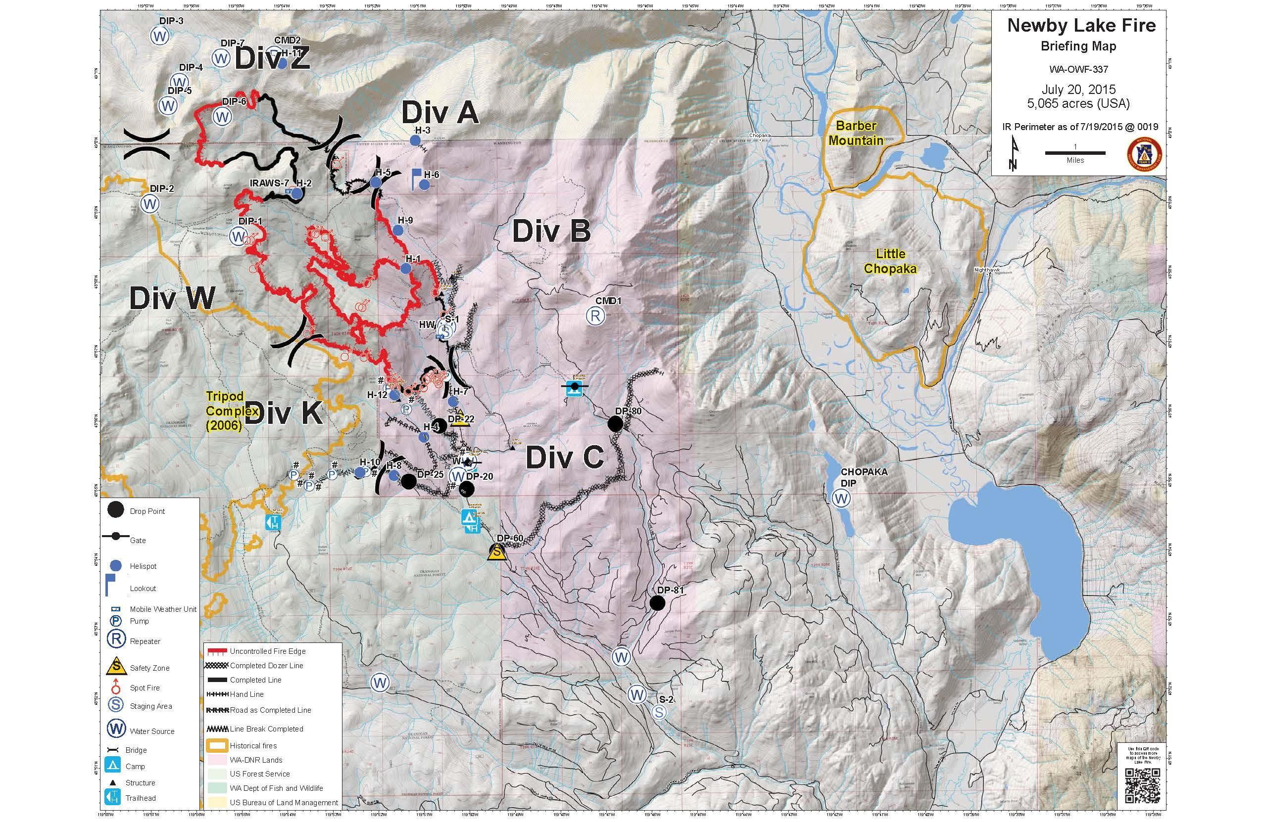
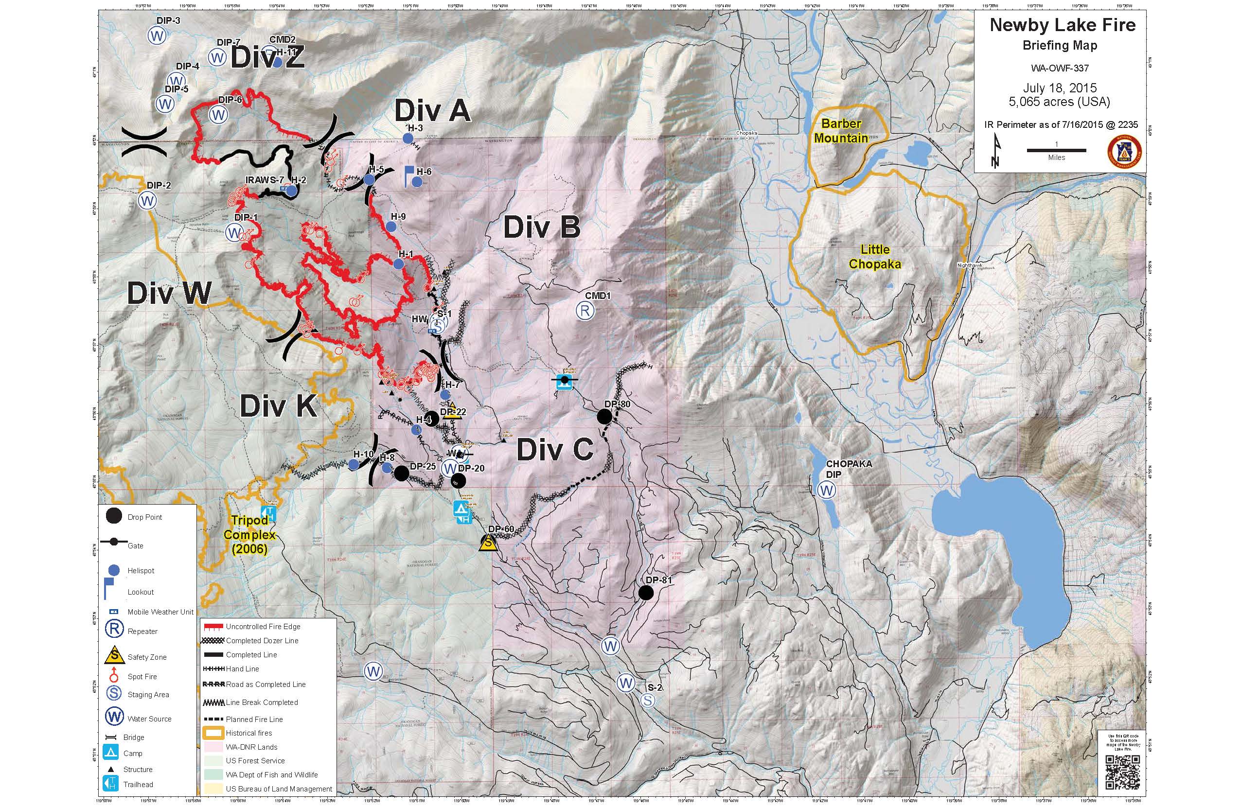
Newby Lake Fire is 95% Contained.  The 45 firefighters that remain assigned to the incident are re-rocking roads, fixing fences and preparing contingencies for response should the fire grow outside its existing perimeter.

Because of the safety concerns associated with falling snags, the remote location and fuel conditions, Newby Lake Fire won’t be declared 100% contained until this winter when fire season is over.   Patrols will continue throughout the season.

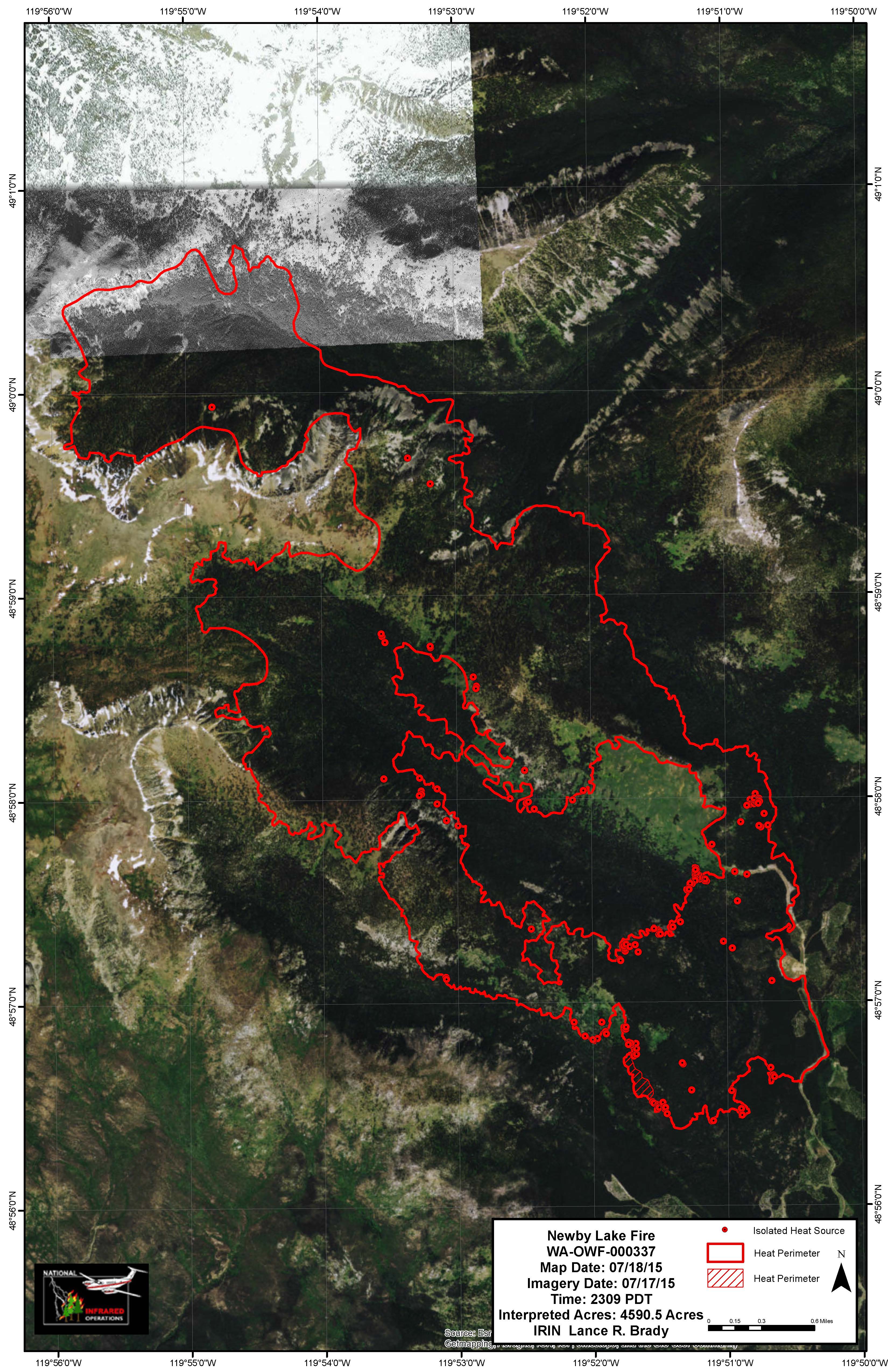
Firefighters today reported visible smokes from within the fire perimeter when cloud cover cleared enough for fuels to dry out.  No smokes were visible in Division B, along the eastern perimeter of the fire.

The contingency planning includes accurately mapping the types and locations of firefighting equipment being kept in place for use in defending containment lines as well as identifying if/when strategies to be used for suppression should the fire begin to spread.  Road improvements necessary for successful implementation of the contingencies is also occurring.

Closures An area closure remains in place on all National Forest Lands and WA DNR lands affected by the fire.  For the most up-to-date trail, road and campground closure information on National Forest and  Washington DNR lands, please contact the appropriate land management agency or visit their websites

Washington DNR: http://www.dnr.wa.gov/managed-lands/forest-and-trust-lands/loomis-and-loup-loup-state-forests 

Okanogan-Wenatchee National Forest:  http://www.fs.usda.gov/okawen/

Newby Lake Fire – Incident Overview

Incident Overview

The Type 1 Pacific Northwest Incident Management Team #3 is transitioning the management of the fire to a Type 3 Incident Management Team. The Type 3 team will assume management of the fire tomorrow at 6:00 am. Ed Lewis, Incident Commander of the Pacific Northwest Team #3 would like to thank the community for its support and all who helped in the fire suppression effort.

Firefighters will continue to scout out the location and construct direct fire line west of the Middle Fork of Toats Coulee Creek to the Tripod Fire scar. Mop up of hot spots at the southeastern and southern sections of the fire will continue. Air patrol of the northern and northeast sectors of the fire will be on-going. Construction of the contingency line in Nine Mile Creek and Branch Creek will also continue.

Basic Information

Current as of 7/20/2015, 6:32:51 PM
Incident Type Wildfire
Cause Lightning/natural
Date of Origin Thursday July 02nd, 2015 approx. 01:00 PM
Location 12 miles NW of Loomis, WA.
Incident Commander Ed Lewis – PNW 3

Current Situation

Total Personnel 329
Size 5,065 Acres
Percent of Perimeter Contained 30%
Fuels Involved Timber (Grass and Understory).
Significant Events The fire is exhibiting a combination of smoldering, creeping and isolated torching. Fire behavior potential rises significantly this afternoon and evening with forecasted high winds and low relative humidity. Isolated torching and short range spotting with potential for 1 to 2 mile runs if fire gets established outside fire lines. Air operations may be hampered by high gusty winds.

Outlook

Planned Actions Division A/Z: Aerial patrol.

Division B: Identify heat sources and mop-up as appropriate.

Division C: Utilize a combination of direct line and cold trail methods west of the North Fork of Toats Coulee Creek in order to check fire spread within the existing perimeter. Continue to mop up from the 4000 road to Toats Coulee. Identify alternate and contingency options.

Division K: In monitor status.

Contingency Groups 1 & 2 are constructing contingency lines to the south and east of the fire along Nine Mile Road and Branch Creek Drainage.

Projected Incident Activity 12 Hours: Isolated torching trees and short range spotting. If a spot or slop over gets established, single/group torching, and long range spotting could occur.

24 Hours: Creeping, smoldering with isolated torching.

48 & 72 Hours: Creeping, smoldering with isolated torching.

Anticipated after 72 Hours: Creeping and smoldering.

Remarks The figure of 5,065 acres accounts for acres within the United States.

Current Weather

Weather Concerns A dry air mass moving into area this afternoon will cause relative humidity to lower towards 20%. Winds from a dry cold front will also hit the fire area this afternoon and cause near critical fire conditions.

Newby Lake Fire – Update

Yesterday’s Activities:

Firefighters continued to secure and mop up the eastern and southern portions of the fire. Crews constructed fire line west from the Middle Fork of Toats Coulee Creek toward the wilderness boundary. The northern and northeast portions of the fire were patrolled by air, and no significant fire activity was detected. Contingency fire line construction within Nine Mile Creek and Branch Creek progressed.

Today’s Activities:

The Type 1 Pacific Northwest Incident Management Team #3 is transitioning the management of the fire to a Type 3 Incident Management Team. The Type 3 team will assume management of the fire tomorrow at 6:00 am. Ed Lewis, Incident Commander of the Pacific Northwest Team #3 would like to thank the community for its support and all who helped in the fire suppression effort.

Firefighters will continue to scout out the location and construct direct fire line west of the Middle Fork of Toats Coulee Creek to the Tripod Fire scar. Mop up of hot spots at the southeastern and southern sections of the fire will continue. Air patrol of the northern and northeast sectors of the fire will be on-going. Construction of the contingency line in Nine Mile Creek and Branch Creek will also continue.

Weather:

Similar temperatures as yesterday in the 80s are predicted for the fire area. Relative humidity will drop to 21%. A dry cold front will pass through the area at approximately 6:00 pm bringing winds out of the west 15-20 mph with gusts to 30 mph.

Closures: An area closure remains in place on all National Forest Lands and WA DNR lands affected by the fire. For the most up-to-date trail, road and campground closure information on National Forest and Washington DNR lands, please contact the appropriate land management agency or visit their websites

Washington DNR: http://www.dnr.wa.gov/managed-lands/forest-and-trust-lands/loomis-and-loup-loup-state-forests

Okanogan-Wenatchee National Forest: http://www.fs.usda.gov/okawen/

Newby Lake Fire – Incident Overview

Basic Information

Current as of 7/19/2015, 8:52:36 PM
Incident Type Wildfire
Cause Lightning/natural
Date of Origin Thursday July 02nd, 2015 approx. 01:00 PM
Location 12 miles NW of Loomis, WA.
Incident Commander Ed Lewis – PNW 3

Current Situation

Total Personnel 403
Size 5,065 Acres
Percent of Perimeter Contained 30%
Fuels Involved Timber (Grass and Understory).
Significant Events Fire behavior includes creeping, smoldering with some isolated torching and short range spotting. Increase fire behavior is possible with outflow winds from thunderstorms.

Outlook

Planned Actions Division A/Z: Aerial patrol.

Division B: Identify heat sources and mop-up as appropriate.

Division C: Utilize a combination of direct line and cold trail methods west of the North Fork of Toats Coulee Creek in order to check fire spread within the existing perimeter. Continue to mop up from the 4000 road to Toats Coulee. Identify alternate and contingency options.

Division K: In monitor status.

Contingency Groups 1 & 2 are constructing contingency lines to the south and east of the fire along Nine Mile Road and Branch Creek Drainage.

Projected Incident Activity 12 Hours: Low spread potential, creeping and a few isolated torching trees. Short range spotting.

24 Hours: Elevated fire activity with warming and drying. Isolated torching and short range spotting.

48 & 72 Hours: Creeping and smoldering with isolated torching and short range spotting

Anticipated after 72 Hours: Creeping and smoldering. Unsettled, moist and cooler weather is forecasted.

Remarks The figure of 5,065 acres accounts for acres within the United States.

Current Weather

Weather Concerns Warming and drying trend will continue with today being the warmest temperatures and lowest relatively humilities in the past week. Winds will be calm. Brief thunderstorms are possible with outflow winds and lightning.

Newby Lake Fire – Update

Yesterday’s Activities: The northern and northeast portions of the fire were patrolled by air, and no significant fire activity was detected.  Firefighters continued to use heat sensing devices to find hot spots near the eastern perimeter of the fire to mop up hot spots.  Crews tied fire line together at the southeast corner of the fire and constructed direct fire line west to the vicinity of Hells Hole.  Contingency fire line within Nine Mile Creek was nearly completed. Branch Creek contingency line construction also progressed.

Today’s Activities:  Firefighters will continue to scout out the location and construct direct fire line west of the Middle Fork of Toats Coulee Creek to the Tripod Fire scar.  Hazard trees will be removed along the fire line to ensure firefighter safety.  Air patrol of the northern and northeast sectors of the fire will be on-going.  The contingency line in Nine Mile Creek and Branch Creek is expected to be completed by end of shift today.  The Type 1 Pacific Northwest Incident Management Team #3 is planning to transition management of the fire to a smaller Type 3 Incident Management Team tomorrow.  The Type 3 team is scheduled to assume management of the fire at 6:00 am on Tuesday.


Weather:  Temperatures are predicted to increase to 80 degrees within the fire area.  Winds will be out of the southeast 4-8 mph shifting to 5-9 mph out of the northwest at approximately 8:00 pm.   Minimum relative humidity is forecast to be 30%.  Brief thunderstorms are possible over the fire area by mid-afternoon accompanied by lightning and down draft winds.  Chance of rain is 50%.

Closures:  An area closure remains in place on all National Forest Lands and WA DNR lands affected by the fire.  For the most up-to-date trail, road and campground closure information on National Forest and  Washington DNR lands, please contact the appropriate land management agency or visit their websites

Washington DNR: http://www.dnr.wa.gov/managed-lands/forest-and-trust-lands/loomis-and-loup-loup-state-forests

Okanogan-Wenatchee National Forest:  http://www.fs.usda.gov/okawen/

Newby Lake Fire – Incident Update

Incident Overview

Firefighters have taken advantage of cool and moist conditions over the past few days to make significant progress in building and securing fire lines. Crews in Canada crews will complete mop up and return to base camp when wind conditions permit helicopter flights. On the east flank of the fire firefighters continue to locate and mop up hot spots with the aid of palm infra-red devices In the southeast area, crews will continue securing the 4000 road. Plumbing is complete with hose lays and pumps on the south end, but many hazard snags will be removed to improve fire lines. Crews will continue to build contingency lines in the Branch Creek and Nine Mile Drainage. Winds out of the north-northwest are expected to peak today and give way to a significant warming and drying trend this weekend.

Basic Information

Current as of 7/18/2015, 8:39:41 PM
Incident Type Wildfire
Cause Lightning/natural
Date of Origin Thursday July 02nd, 2015 approx. 01:00 PM
Location 12 miles NW of Loomis, WA.
Incident Commander Ed Lewis – PNW 3

Current Situation

Total Personnel 458
Size 5,065 Acres
Percent of Perimeter Contained 25%
Fuels Involved Timber (Grass and Understory).
Significant Events Fire behavior is minimal. It includes creeping, isolated torching and smoldering. Isolated torching and short range spotting was observed late afternoon.

Outlook

Planned Actions Division A/Z: Aerial patrol.

Division B: Identify heat sources and mop-up as appropriate.

Division C: Utilize a combination of direct line and cold trail methods west of the 4000 road to the North Fork of Toats Coulee Creek in order to check fire spread within the existing perimeter. In addition, prepare control lines for potential burnout operations.

Division K: Scout line opportunities from the Wilderness boundary at Hells Hole to the Tripod fire scar.

Contingency Groups 1 & 2 are constructing contingency lines to the south and east of the fire along Nine Mile Road and Branch Creek Drainage.

Projected Incident Activity 12 Hours: Low spread potential, creeping and a few isolated torching trees. Short range spotting.

24 Hours: Elevated fire activity possible with warming and drying. Isolated torching and short range spotting.

48 & 72 Hours: Isolated torching and short range spotting

Anticipated after 72 Hours: Increased fire activity with continued drying and diurnal winds. Single tree and small group torching possible with short range spotting.

Remarks The figure of 5,065 acres accounts for acres within the United States.

Current Weather

Weather Concerns Warming and drying trend will continue. Temperatures will be at its warmest and relatively humilities will be at its lowest in over a week. Winds will be calm.

Newby Lake Fire Update

Yesterday’s Activities: After completing mop up on the northern end of the fire in Canada two hot shot crews were transported out by helicopter and returned to base camp. A helicopter with an infra-red operator was used to assist firefighters on the ground in locating areas of heat along the fire line on the east area of the fire. Firefighters experienced windy conditions on the southeast portion of the fire early in the day. They were able to return to work installing hose lay after the wind subsided.

Firefighters cleared snags and improved line at the south end of the fire. Good progress was made on construction of contingency lines southeast of the fire perimeter. Contingency lines within Branch Creek and Nine Mile Drainage are expected to be tied in together on Saturday. These lines are being built in case the fire escapes current patrol lines.

Today’s Activities: A helicopter with a palm infra-red operator will continue on the east fire line detecting hot spots near the fire line. Once located, the hot spots will be mapped and the infornation relayed to firefighters on the ground who will mop up the targeted areas. On the southern perimeter of the fire crews will continue to cool down hot spots and build fire line directly adjacent to the fire where it’s safe to do so.
Crews will improve indirect line off the 4512 road west to the 2006 Tripod Fire. Firefighters will continue to extend the contingency lines in the Branch Creek and Nine Mile Drainage.

Weather: Weather conditions are warming and drying for the weekend. Lighter winds are expected to be 6 miles per hour. Temperatures continue to increase and are expected to reach 76 degrees at the fire. Relative humidity will be in the 24% range.
Closures: An area closure remains in place on all National Forest Lands and WA DNR lands affected by the fire. For the most up-to-date trail, road and campground closure information on National Forest and Washington DNR lands, please contact the appropriate land management agency or visit their websites
Washington DNR: www.dnr.wa.gov/managed-lands/forest-and-trust-lands/loomis-and-loup-loup-state-forests
Okanogan-Wenatchee National Forest: www.fs.usda.gov/okawen/